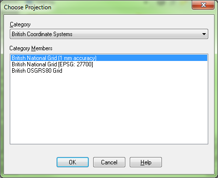
A problem frequently encountered with sharing data between MapInfo and ArcGIS is that the British National Grid projection used by ArcGIS is accurate to 1 mm, whilst the standard projection used by MapInfo is not. This can be an issue, as boundary data that matches Ordnance Survey MasterMap data in MapInfo will appear to be poorly mapped (albeit by a just a few cm) when compared with MasterMap data in ArcGIS.
In order to resolve this, MapInfo introduced a 1 mm accuracy projection, which can be found under Projection... when you create a table or save a copy of an existing table. However, this is not a default option, so even when saving a copy of data already in the 1 mm precision projection MapInfo will automatically default to the standard projection. This makes it very easy to accidentally reduce the quality of your data if you forget to actively select the 1 mm precision projection.
Fortunately there is a relatively simple way to ensure that MapInfo always defaults to the 1 mm projection:
-
Navigate to the MapInfo folder under program files (e.g. C:\Program Files (x86)\MapInfo\Professional).
-
Locate the MAPINFOW.PRJ file.

-
Backup the MAPINFOW.PRJ file, in case you make a mistake.
-
Open the MAPINFOW.PRJ file in a text editor (e.g. notepad).
-
Search for ‘British’, which will find a section of text that looks like this:
"--- British Coordinate Systems ---"
"British National Grid\p27700", 8, 79, 7, -2, 49, 0.9996012717, 400000, -100000
"British National Grid (1 mm accuracy)", 2008, 79, 7, -2, 49,0.9996012717, 400000, -100000, 0, 0, 2000000, 2000000
"British OSGRS80 Grid", 8, 33, 7, -2, 49, 0.9996012717, 400000, -100000
-
Move the third line of this text up one so that it becomes the second:
"--- British Coordinate Systems ---"
"British National Grid (1 mm accuracy)", 2008, 79, 7, -2, 49,0.9996012717, 400000, -100000, 0, 0, 2000000, 2000000
"British National Grid\p27700", 8, 79, 7, -2, 49, 0.9996012717, 400000, -100000
"British OSGRS80 Grid", 8, 33, 7, -2, 49, 0.9996012717, 400000, -100000
This change moves the 1 mm accuracy projection to the top of the Category Members selector under the British Coordinate Systems Category in the Choose Projection dialogue box of MapInfo, automatically making it the default option (as shown in the picture). If you want to use the standard projection then you just need to select 'British National Grid [EPSG: 27700]' from the dialogue instead.